Bangalore Metro Route Map: Timing | Lines | Stations
Exploring Bangalore becomes easier with the Bangalore Metro Route Map that helps commuters travel efficiently across the city. Bangalore’s metro system has grown rapidly, connecting key areas and reducing traffic congestion. This blog post explains the metro’s lines, timings, stations, and how to use the route map for a smooth journey.
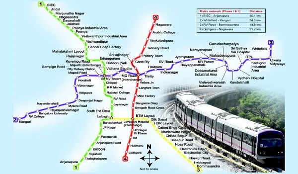
Overview of Bangalore Metro System
Bangalore Metro, also called Namma Metro, stands as one of India’s most modern urban transit systems. It aims to provide a clean, fast, and reliable mode of transport for millions. The network features multiple lines, each serving distinct corridors and neighborhoods. The metro connects residential areas, business hubs, and entertainment centers to improve daily commuting.
Understanding the Bangalore Metro Route Map
The Bangalore Metro Route Map acts as a guide to navigate the entire metro network. It clearly marks all operational lines and stations, making it simple for travelers to plan their trips. The map displays interchange points where commuters can switch lines to reach their destinations faster.
Key elements of the metro route map include:
- Color-coded lines for easy recognition
- Station names clearly labeled
- Interchange stations highlighted
- End-to-end routes visible
This design supports quick comprehension even for first-time users.
Metro Lines and Their Routes
Bangalore Metro operates two main lines: the Purple Line and the Green Line. Each line covers a significant portion of the city and intersects at critical hubs to provide smooth transfers.
Purple Line: East-West Corridor
The Purple Line stretches across the city from east to west. It passes through busy commercial areas and connects major IT parks, shopping districts, and residential zones. This line serves as a vital artery for daily commuters and tourists alike.
Green Line: North-South Corridor
The Green Line runs from north to south, linking important residential localities with central business districts. It provides access to government offices, educational institutions, and hospitals along the route. The Green Line plays a crucial role in connecting suburban areas to the city center.
Stations on the Bangalore Metro Network
The metro stations form the backbone of the system, enabling passengers to board and alight conveniently. Each station features modern facilities such as ticket counters, automated fare collection, security checks, and accessibility options.
Major Stations on Purple Line
- Baiyappanahalli
- MG Road
- Majestic (Interchange Station)
- Kengeri
Major Stations on Green Line
- Nagasandra
- Majestic (Interchange Station)
- Yelachenahalli
- Silk Institute
These stations facilitate smooth passenger flow and act as important nodes within the network.
Interchange Stations for Seamless Transfers
Majestic station stands as the key interchange point between the Purple and Green Lines. It allows passengers to switch lines without exiting the metro premises. This interchange boosts connectivity and reduces travel time.
Additional interchange stations enhance route flexibility and cater to growing commuter demand.
Bangalore Metro Operating Hours and Timings
Namma Metro operates daily, offering early morning to late-night services to cover peak and off-peak hours. The timings provide commuters with ample options to plan their trips around work, leisure, or errands.
- Weekday schedules ensure frequent trains during rush hours
- Weekend timings accommodate leisure travelers
- Last train timings help plan return journeys effectively
Checking the metro schedule before traveling helps avoid waiting times and ensures timely arrival.
How to Use the Bangalore Metro Route Map Effectively
Using the metro route map simplifies travel across Bangalore. Follow these steps for a hassle-free metro journey:
- Identify your starting station and destination on the map.
- Determine the line(s) you need to travel on.
- Check if an interchange station lies on your route.
- Estimate the number of stops to calculate travel time.
- Use mobile apps or station information for live updates.
This preparation helps save time and avoid confusion during your commute.
Benefits of Traveling by Bangalore Metro
The metro offers numerous advantages compared to road transport:
- Avoid traffic jams and road delays
- Travel comfortably in air-conditioned coaches
- Save money on fuel and parking
- Reduce carbon footprint by using public transit
- Reach destinations faster with dedicated metro corridors
These benefits make the metro the preferred choice for Bangalore’s growing population.
Future Expansion Plans for Bangalore Metro
Bangalore Metro continues to expand its network to serve more neighborhoods. Upcoming phases include new lines and extensions to existing routes. These projects aim to enhance connectivity to airports, IT hubs, and residential areas.
Planning and construction are underway to bring more stations online soon. This expansion will further reduce travel time and improve convenience for commuters.
Accessibility Features on Bangalore Metro
The metro ensures inclusivity by offering facilities for differently-abled passengers:
- Elevators and ramps at all stations
- Reserved seating for elderly and disabled
- Tactile paving for visually impaired
- Announcements and digital displays for station info
Such measures promote comfortable and safe travel for all commuters.
Tips for First-Time Bangalore Metro Riders
Riding the metro for the first time can feel overwhelming. Keep these tips in mind to enjoy a smooth experience:
- Buy tokens or smart cards before boarding
- Enter and exit through designated gates
- Stand on the left side of escalators to allow others to pass
- Keep your belongings close and secure
- Follow metro staff instructions and safety signs
These simple practices ensure a safe and pleasant journey.
Booking Tickets and Using Smart Cards
Bangalore Metro offers multiple payment options:
- Single journey tokens for occasional travelers
- Reloadable smart cards for frequent commuters
Smart cards save time by avoiding queues and offer discounted fares. Recharge points and kiosks exist at every station for convenience.
Safety and Security on Bangalore Metro
The metro maintains strict security measures to protect passengers:
- CCTV surveillance throughout trains and stations
- Trained security personnel on duty
- Emergency communication systems onboard
- Regular safety drills and checks
These efforts create a secure environment and build commuter confidence.
Popular Destinations Accessible by Bangalore Metro
The metro connects key landmarks and popular spots across Bangalore, such as:
- Shopping malls and entertainment zones
- IT parks and office complexes
- Hospitals and educational institutions
- Tourist attractions and cultural centers
Travelers find the metro a convenient way to reach these destinations without the hassle of road traffic.
Impact of Bangalore Metro on City Traffic
The introduction of the metro has significantly reduced traffic congestion on major roads. Many commuters shifted from private vehicles and buses to metro trains. This shift lowers air pollution and improves overall urban mobility.
Using Bangalore Metro Apps and Online Resources
Several apps provide real-time updates, route planning, and ticket booking for Bangalore Metro. These digital tools assist travelers in:
- Checking train arrival times
- Planning routes with minimal transfers
- Receiving alerts on delays or changes
- Finding nearby metro stations
Leveraging technology enhances the commuting experience and reduces uncertainty.
How to Stay Updated on Bangalore Metro News
Stay informed about changes in metro routes, timings, and expansions by following official sources and news outlets. Signing up for newsletters or alerts helps you receive timely updates directly on your device.
Environmental Benefits of Using Bangalore Metro
By opting for the metro, commuters contribute to reducing the city’s carbon footprint. The electric trains produce less pollution than conventional vehicles, promoting cleaner air and sustainable urban living.
Conclusion
Understanding the Bangalore Metro Route Map, timings, lines, and stations empowers you to travel confidently across the city. The system provides an efficient, eco-friendly alternative to road transport. Use the route map to plan your journeys, save time, and enjoy the comfort of metro travel.
For detailed information or assistance with routes and tickets, please Contact Us to get expert guidance on navigating Bangalore Metro smoothly.
Frequently Asked Questions
1. How can I read and use the Bangalore Metro Route Map effectively?
You can use the metro route map by identifying your starting point and destination, checking the line colors, and locating interchange stations if needed. The map helps plan the fastest route and estimate travel stops.
2. What are the operating hours of Bangalore Metro trains?
Bangalore Metro operates from early morning until late at night, with frequent trains during peak hours and slightly reduced service during off-peak times and weekends. Exact timings vary by line and day.
3. Which stations serve as interchange points in Bangalore Metro?
Majestic station is the primary interchange connecting the Purple and Green Lines. It allows passengers to switch lines easily without exiting the station premises.
4. Can I use a smart card for all Bangalore Metro lines?
Yes, smart cards work across all Bangalore Metro lines. They provide a convenient and faster way to pay for journeys and are reloadable at stations and kiosks.
5. How safe is traveling on Bangalore Metro?
Bangalore Metro maintains strict security with CCTV surveillance, trained personnel, and emergency communication systems. Safety protocols ensure a secure environment for all passengers.