The unpredictability of urban flooding has become a growing concern across cities and municipalities. As climate patterns shift and rainfall intensity rises, aging infrastructure struggles to keep up. Traditional stormwater systems, designed decades ago for slower Stormwater Management, steadier rainfall, are proving inadequate in the face of today’s sudden deluges. The solution? A smarter, more adaptive approach powered by real-time telemetry.
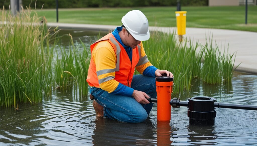
At the heart of this transformation is the ability to monitor stormwater systems as they function, not just in theory or through scheduled checks. With remote water level monitoring integrated into drainage basins, retention ponds, and sewer systems, utility teams gain real-time visibility—enabling proactive decisions that prevent flooding, property damage, and infrastructure strain.
The New Reality of Urban Flooding
Cities are concrete landscapes where water has fewer places to go. Pavement, rooftops, and roads divert rainfall into storm drains, which often lead to combined sewer systems. When a sudden storm dumps inches of rain in minutes, those systems are quickly overwhelmed.
This isn’t just an infrastructure issue—it’s a public safety hazard. Streets flood, basements back up, and critical assets like power substations or hospitals can be threatened. The cost isn’t only in damages but in lost time, productivity, and sometimes lives.
What urban planners and utilities need isn’t just more pipe—it’s more intelligence.
What Real-Time Telemetry Actually Delivers
Telemetry goes beyond sensors. It’s a full ecosystem of sensing, communicating, analyzing, and responding. Smart telemetry units installed at key drainage points capture data on flow rates, water levels, rainfall intensity, and more. This data is transmitted instantly via cellular or LPWAN networks to a cloud-based dashboard.
Operators no longer wait for reports—they see the system’s behavior unfold in real time. A culvert backing up? An alert is triggered. A sudden rise in basin levels? Teams are dispatched. With this level of responsiveness, cities move from reactive clean-up to preventive action.
And this isn’t only for crisis moments. During normal operations, telemetry helps utilities optimize system performance, identify chokepoints, and plan upgrades based on actual usage, not assumptions.
Intelligent Infrastructure Without Digging Up the City
One of the most powerful aspects of real-time telemetry is its non-invasive implementation. Cities can modernize stormwater infrastructure without massive construction projects. Sensors and communication modules are added to existing structures, feeding data into centralized software tools.
This means cities of all sizes—even those with tight budgets—can leapfrog into smarter water management. Instead of tearing out streets or replacing miles of pipe, they gain intelligence from the infrastructure they already have.
Smart telemetry turns static infrastructure into dynamic systems—networks that learn, adapt, and respond to real conditions.
The Predictive Edge
While real-time visibility is a game-changer, the real magic lies in forecasting. With enough historical and live data, cities can build predictive models. These models simulate how a storm will impact various drainage zones before the first drop of rain even hits the ground.
For example, if a forecast predicts heavy rain in a particular area, preemptive actions can be taken: water levels in retention ponds can be lowered in advance, temporary barriers deployed, and vulnerable intersections monitored more closely.
It’s no longer about reacting quickly. It’s about being one step ahead.
Empowering Field Teams with Smart Alerts
A telemetry system isn’t just for control rooms—it empowers field operations. Technicians receive instant alerts to their mobile devices, complete with geolocation and severity indicators. This means faster, smarter response during heavy rainfall events.
Imagine a field crew seeing an alert about a rising storm drain on a specific block. They can inspect it, clear debris, and confirm functionality before the problem escalates. No more guesswork or blanket responses. Just precise, efficient action.
Integrating with Emergency Response and Urban Planning
Real-time telemetry isn’t a siloed system—it connects across city services. Emergency response teams use the same data to plan road closures or evacuations. Urban planners analyze stormwater data to inform zoning decisions, green infrastructure placement, and building code updates.
A flooded intersection today can become the blueprint for tomorrow’s permeable pavement pilot project. A consistently overflowing retention pond may signal the need for a new wetland buffer zone. Telemetry data turns short-term response into long-term resilience.
Adaptable Technology for a Changing Climate
Storm patterns aren’t just getting more intense—they’re getting more erratic. Some cities experience flash floods after long dry spells, while others see back-to-back storms that tax drainage systems.
Real-time telemetry is flexible by design. Its modular architecture means sensors can be added as cities expand. Its software evolves with machine learning, improving forecasts and decision trees over time.
This adaptability is essential. Cities need systems that grow with them—intelligent infrastructure that doesn’t just survive change, but thrives in it.
From Data to Decisions: Making It Actionable
Collecting stormwater data is one thing. Making sense of it is another. That’s why modern telemetry platforms prioritize clarity and usability. Dashboards are visual, intuitive, and customizable to each city’s priorities.
Decision-makers can view maps of current system status, overlay weather predictions, and simulate scenarios to test their response strategies. They can generate reports that demonstrate ROI or justify funding requests for future upgrades.
The result is a data-rich environment where every drop of rain becomes part of a smarter strategy.
Real-World Impact Without the Hype
While smart cities and IoT buzzwords abound, the real value of stormwater telemetry lies in its quiet impact. Fewer flooded basements. Safer intersections. Less emergency overtime. More informed planning.
Residents may never see the sensors, but they’ll feel the benefits—in dry roads, uninterrupted commutes, and cities that bounce back quicker after storms.
And for utility managers, it’s the peace of mind that comes from knowing they have eyes on every corner of their network, day and night.
Looking Ahead: Smarter Cities Begin Beneath Our Feet
We often think of smart cities in terms of 5G towers and autonomous cars. But beneath the surface, it’s the flow of water—and how we manage it—that defines a city’s resilience.
Real-time telemetry is turning stormwater from a chaotic force into a controlled resource. It’s helping cities evolve without starting from scratch. And it’s making invisible systems visible, so we can manage them better.
As urban populations grow and weather extremes become more common, the importance of stormwater intelligence will only rise. And with the right technology in place, cities won’t just weather the storm—they’ll outsmart it.